
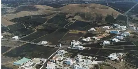
The municipality of Tinajo occupies the west center of the island and is marked by its volcanic origin, mainly due to the eruptions of Timanfaya (1730-1736) and Tinguatón (1824).
A fact that, contrary to what it may seem, has allowed the municipality to become an agricultural area par excellence. This is due to the fact that their crops, made from the ash (rofe or picón) expelled during volcanic eruptions, conserve moisture very well and achieve excellent conditions of extraordinary quality. despite the lack of rain.
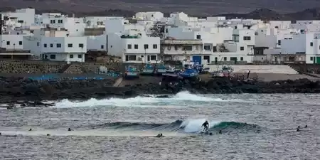
Currently, tourism, especially sports tourism, is booming in the town. The fact of having the Club La Santa, one of the most complete sports centers in the world and where numerous elite athletes spend long periods of time every year, added to the spectacular waves of La Santa , one of the best places in the world for surfing, have contributed to this success.
We must not forget the attraction of the Timanfaya National Park, which it shares with the municipality of Yaiza.
It also belongs to Tinajo La Vegueta, a place of enormous hamlets belonging to the nobility that relives the times of prosperity of Lanzarote.
In the town of Mancha Blanca there is a small sanctuary where Nuestra Señora de los Dolores, patron saint of Lanzarote, is venerated. Better known for the Virgin of the Volcanoes.
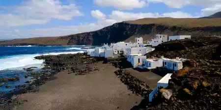
The towns of La Santa, La Vegueta, Mancha Blanca, El Cuchillo, Tinguaton belong to the municipality of Tinajo and Tenesar
Around 1650, Tinajo was just a very poor little town. The legendary Ana Viciosa, wife of Governor Juan de León Moxica, lady of Montaña Clara, by concession of the Marquis of Lanzarote, practically dominated the few inhabitants of the town, scarcely a hundred. .
The hermitage dedicated to San Roque already appears in 1679, although it was enlarged in 1738. to the category of second parish in June 1792.
It is at the beginning of the 19th century when this municipality slowly begins its first steps towards civilization and progress. Until that time their lands had been barren pastures.
Also at the beginning of this century, on January 26, 1802, Tinajo acquired its municipal independence.
Repeatedly threatened by volcanic eruptions on the Island, lava flows were diverted harmlessly. Due to the protection received from the Virgen de los Dolores during the eruption from 1730 to 1736, the church was erected. in Mancha Blanca the Sanctuary of the Virgin of the Volcanoes, of great devotion throughout the Island.
It occupies the central-western sector of Lanzarote, its limits forming a kind of arch, which opens to the sea to the northwest.
Its eastern border with Teguise starts from the vicinity of La Isleta, to extend in an almost straight line, which continues through San Bartolomé. Next, and continuing to the south, another straight line marks the border with Tías, while also to the south and southwest, Yaiza appears. The divide with the latter, part of the area of the Peña Palomas volcano, crosses the Montañas del Fuego and ends near Punta Roncador.
The wide coastline offers the characteristic aspect of the coastal badlands to the south. historical eruptions, giving rise to a rocky coast, with some beaches. Towards its central part, there is a cliff (Caletón de Las Animas) and then, already in the northernmost section, it descends again, appearing the curious projection of La Isleta, separated by the channel of El Río.< /p>
A series of mountains, which correspond to volcanic buildings, are aligned throughout the term, giving rise to a succession of intercollinar valleys. However, it is the historical volcanism that defines a large part of the landscape of the municipality, especially in its western and southern sectors. The eruptions that took place from 1730 to 1736, in Timanfaya, radically transformed the space. They appear like this agglomerations of great complexity, authentic nuclei of this eruption, in the Macizo del Fuego, and to a lesser extent in the whole of Pico Partido; alignments such as that of the calderas of Sta. Catalina and Colorada,...
Some buildings stand out, such as the spectacular Los Cuervos or Coranzoncillo caldera, a wide series of minor volcanic devices called homitos, or the extensive lava spills.
Sometimes, the lavas surround, but do not cover, large areas, giving rise to the so-called islets. This is the case of the well-known Islote de Hilario, in Timanfaya, or the spectacular Caldera Blanca, an enormous volcanic cone (Series III). Finally, in 1824, a triple eruptive manifestation took place in Lanzarote, which presented the Nuevo del Fuego and Tinguatóno Volcán Nuevo volcanoes in the region.
In this way, it will be the eastern sector of the term, along a series of plains and meadows, interspersed between hills and mountains, where both the population and the best cultivation areas. These are developed, either in natural or artificial sanding, jable, topsails, and even, already in the La Quemada area, in holes made in the lava flows.
The low altitude of the term determines climatic characteristics marked by aridity, although its open disposition to the trade winds, favors greater contributions of humidity. The original plant cover has been displaced by the development of crops and the occupation of the historical lavas, giving rise to a scarce replacement vegetation, with xerophilous species.
Tinajo is one of the most important agricultural municipalities in Lanzarote, to which the quality of its soils and its good orientation to the trade winds undoubtedly contribute.
They are given here. practically all the peculiarities of Lanzarote crops: the gavias, the jable, the natural and artificial sanded ones, etc.
Women and children also dedicate themselves to agriculture part-time, thus achieving maintain a large cultivated area.
The most important products are onions, followed by vineyards, legumes and vegetables, millet, sweet potatoes, potatoes and some tobacco and prickly pear.
However, it is the tertiary sector and, within it, the Services subsector, which occupies most of the labor assets of the municipality; tourism is located in La Santa, in a place called El Islote.
In importance follows the secondary sector, in which construction stands out, with agriculture within the primary sector offering the most employment, followed by fishing.
It is of interest to visit the municipal district. As Agustín de la Hoz well describes, the typical construction of the municipality is a point to consider in a cultural visit to this term.
The parish church of San Roque stands out. As we have indicated, the primitive hermitage undergoes extensions and reforms. Visiting it, we can contemplate its beautiful naves and its Mudejar ceiling.
This church houses a Christ attributed to Luján Pérez and a Virgin of Candelaria, the work of Luján's disciple, Fernando Estevez.
It is also of interest the sanctuary of Nuestra Señora de los Volcanes, built by the neighbors in gratitude for the protection received from the Virgin in the eruptions of 1730. It was opened for worship around 1781, and the current sanctuary was finished in 1861 once the first building was restored.
The Timanfaya National Park includes the area affected by the 1730-36 eruptions, as well as the as for that of 1824 (Volcán Nuevo). On the Islet of Hilario, with a curious historical background, a unique phenomenon of thermal anomalies is observed, due to the heating of the aquifer, which causes the rise of water vapor and the overheating of the ground, registering very high temperatures a few centimeters from the surface.
The Natural Park of La Geria houses a large part of the area affected by the eruptions of the 18th and 19th centuries, which are not included in the National Park. Of great ecological value are the islets, such as the Caldera Blanca, Islote del Cortijo,... A special curiosity is the eruption of Tinguatón (1824), with unique forms in Canarian volcanism, such as the series of chasms or wells (Simas del Diablo), product of hydromagmatic activity.
The festival dedicated to the Virgin of the Volcanoes stands out (September 15). It is related to the eruptions of the 18th century, when on April 16, 1736, tradition indicates that the intersection In de la Virgen, he made the lavas stop on their way.The subsequent construction of the hermitage, in that place, is also involved in a surprising story, as well as the intervention of the Virgin in the appeasement of the 1824 eruption. An outstanding part of the festival is the representation of different historical events, the work of Juan Brito.
Perpetuating a centuries-old tradition, the work of the old potter Doña Dorotea is continued by her relatives. Among other pieces, the original boyfriends of the Moj6n stand out. The typical hats are also made in the municipality.
A place with a curious history is the so-called Cueva de Ana Viciosa. Located at a point of difficult access next to the coast, it was a fortified place and a place of amorous encounters for its licentious owner.
The wines of the area have a famous reputation.
The municipality of Tinajo is made up of seven population centers, each reflecting the island’s volcanic soul and rural charm. These include the main town of Tinajo, as well as La Santa, El Cuchillo, Mancha Blanca, Tinguatón, and Caleta de Caballo.
Surrounded by dramatic landscapes, including parts of Timanfaya National Park, the towns of Tinajo are ideal for visitors seeking a more authentic and peaceful side of Lanzarote. Whether you're exploring the surfer’s paradise of La Santa, the religious heart of Mancha Blanca, or the quiet village life in Tao and El Cuchillo, Tinajo offers a unique window into the island’s heritage and nature.


White Spot is most famous for the church of Los Dolores, patron saint of the island of Lanzarote.

El Cuchillo is a small and quiet town with scattered houses, located very close to Tinajo.

Promoción y turismo en internet