A large part of the municipality of just over 106 square km and with almost five thousand inhabitants, it can be seen by accessing the northern highway, through Los Valles (Teguise), passing through the Santuario de las Nieves, Las Peñas del Chache (highest peak of the island), visiting the small forest, the only wooded area on the island.
Continuing north along the Famara cliffs, you can see the Chinijo Archipelago from above.
Descending on the southeast side we find órzola, the embarkation point to visit La Graciosa. Then we will find La Cueva de los Verdes and Los Jameos de Agua and the other coastal towns of the municipality: Punta Mujeres and Arrieta.
The municipality of Haría, like all those on the island of Lanzarote, has had a sad past, based on misery, slavery and, later, emigration in search of family sustenance.< /p>
Unfortunately, even the name by which the natives used to call our oldest settlements in pre-Hispanic times is unknown; It was the conquerors who gave each town or place the names that were most significant to them; today only a few of the primitives remain.
It is considered that the name of the municipal capital, Haría, was Faria at the time of the conquest, which later degenerated to the point that the Teberitese dictionary gives it six denominations: Haría, Aria, Faria, Haria, Hária and Harya.
It had a church since 1619, although a gust of wind ruined it. The building was completed in 1956, leaving only the tower standing.
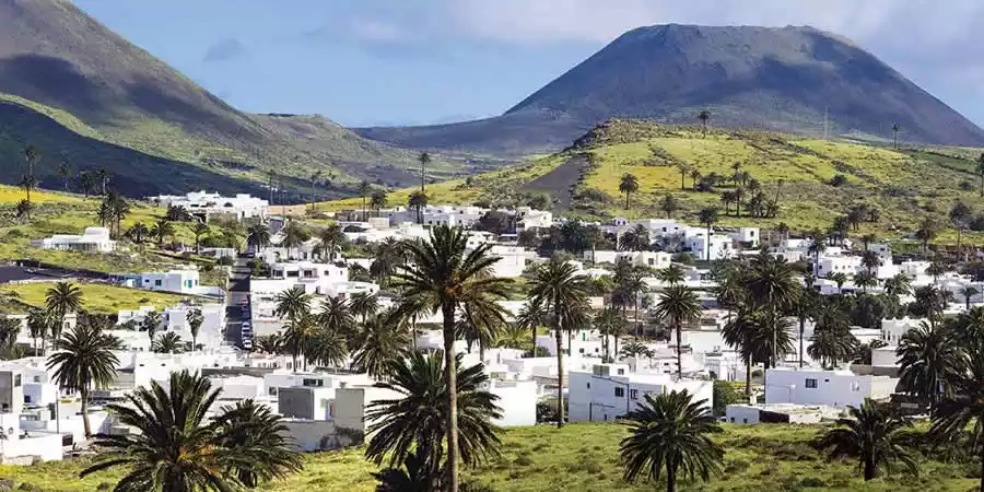
Also like the other municipalities of Lanzarote, it was the victim of many attacks and piracies, highlighting that of 1618, when inhabitants of Teguise came to take refuge in the Cueva de los Verdes, being betrayed; or the one that, according to Leoncio Rodríguez, destroyed much of the beautiful palm grove that makes the town proud (Gregorio Barreto Viñoly).
It occupies the extreme north of Lanzarote, being limited to the south, only with the municipality of Teguise, through a dividing line that crosses the island, from El Charco del Palo to the east to the Playa de Famara to the west.
The relief determines the settlement of the population to the west, mostly along a series of parallel valleys, which descend from the old Famara-Guatifay massif. On the western coast there are a series of nuclei, from Mala to Órzola, the latter place where you embark for Caleta del Sebo in La Graciosa . In general, the coast is very varied, from the impressive cliffs, with small platforms, in the western sector, to the low-lying areas, with some coves, in the eastern sector.
The old massif of Famara-Guatifay, with the highest island height, is part of the first construction stage of the island. It offers the image left by the erosive dismantling of the Famara cliffs, where half of the massif has disappeared, or wide U-shaped valleys such as Temisas or Haría itself. Subsequent eruptions have modified the relief, up to the recent eruptions of La Quemada, La Corona and Los Helechos. This phase of volcanic activity transformed the substantially the northwestern sector of the island, creating an extensive bad country.
The highest altitude, although low, as well as as well as the orientation of the relief, determine that it is the municipality with the highest rainfall records. The greatest humidity is felt in areas with a great wealth of vegetation, such as the Famara cliffs. The palm groves are also an outstanding note, as in the case of Haría.
The main economic activity of the municipality of Haría is agriculture, which is influenced by the fact that it is the most favored by climatic conditions due to its orientation and relief.
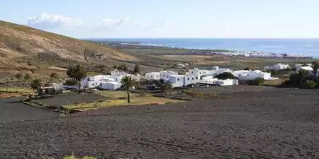
Leguminous crops, potatoes, cereals, vines, millet, garlic, cochineal and onion dominate, the latter being recently introduced, as they were crops from the southern zone of the island. All of them are made in sanded.
The property of the land is very spread out, the plots being separated by stone walls; This characteristic, together with those of the enarenados, makes mechanization of the field difficult: the most modern tool is the so-called devil, together with the tanganilla.
Part of the population is dedicated to the tourist sector, since some of the attractive points of the island are found within the municipal area: the Mirador del Río, the Cueva de los Verdes, the Jameos del Agua and some urbanizations.
With San Juan (in June) and until July 1 with the festival of El Cristo de la Sed, the main festivals of the municipality take place in Haría, although as occurs throughout the Archipelago, each neighborhood celebrates its own festivities. For the night of San Juan, bonfires are made and Facundo is burned, a character who symbolizes everything bad that has to disappear consumed by fire. The descent of the palm tree was a recent festival, which tried to recover old traditions and yet has not had continuity over time. Linked to the palm tree are, precisely, some of the crafts that are produced in the area, in the case of the basketry with pirgano. Others are reed basketry, thread rosettes,... Also of interest are all the tasks that revolve around the breeding, harvesting and treatment of cochineal in Mala. The windmill of this town is one of the few survivors of another time not so remote.
There are two Natural Parks, which include some of the most outstanding attractions of Lanzarote. In the Parque del Volcán de La Corona, the volcanic cone of the Montaña Corona stands out, as well as its extensive badlands, where the Cave de los Verdes and los Jameos del Agua. from here The Atlantis tunnel starts, the largest known underwater cave, with a very peculiar fauna. On the opposite bank, on the Famara cliffs, is the River Viewpoint, which offers an unbeatable view of the Chinijo Archipelago. Its cliffs keep the largest insular botanical reserve, with innumerable endemisms.
The different valleys offer great scenic interest, such as Haría, with its thousands of palm trees.
There is a recreational space called El Bosquecillo (Cumbres de Famara) and it is accessed from Haría via the Peñas del Chache path.
From a cultural point of view, the inhabited points of the municipality are of interest, with their peculiar architecture and careful cleanliness, which show the love of its inhabitants for their land.
The municipal capital, Haría, has a beautiful square. It has a Popular Sacred Museum, in which various images and beautiful religious objects for worship are preserved.
The hermitage of San Juan, which dates back to the 17th century, also deserves a special mention.
For the parish church he carved Luján Pérez a Pregnant Virgin, one of the most pleasant and humanized invocations of his plastic work.
The municipality of Haría, located in the north of Lanzarote, is composed of ten distinct villages and settlements, each with its own personality and charm. From the cultural richness of the main town Haría, known for its Saturday craft market and beautiful Valley of a Thousand Palms, to the coastal serenity of Órzola, the gateway to La Graciosa island, every corner of this municipality offers something unique.
Other picturesque villages like Máguez, Ye, Punta Mujeres, and Arrieta are perfect for discovering the island’s traditional architecture, natural swimming pools, and peaceful way of life. These towns are ideal for visitors who want to explore authentic Lanzarote, far from the tourist crowds, and immerse themselves in the island’s local culture, volcanic landscapes, and warm hospitality.

Charco del Palo is a naturist resort located on the northeast coast of Lanzarote


Punta Mujeres is a coastal town in the municipality of Haría, famous for its natural pools.


Promoción y turismo en internet