
The municipality of Tías is located on the southern slope of the center of the island, with an area of 64.61 square kilometers and a perimeter of 37.719 kilometers, whose limits are: north, Tinajo; to the south, the sea; to the east, San Bartolomé, and to the west, Yaiza.
The capital of the municipality, Tías, rises on a gentle slope and its houses are placed in steps on it, presided over by the Church Ntra. Mrs. of La Candelaria.
On its southern coast is the town of Puerto del Carmem, which passed It went from being a small, sparsely populated fishing village to becoming one of the most popular tourist areas in the Canary Islands. Its notable success is largely due to the cleanliness and conservation of the more than 6 km of beaches that line its coastline, the tranquility of its waters and the peaceful and grateful natural environment that has been created. managed to create.
In the interior of Tías we find the Valley of La Geria, a protected area formed on ashes and volcanic lava, ideal for growing vines. On both sides of the Valle de la Geria are the wineries, which allow you to check the good craftsmanship of the quality of Lanzarote wines.
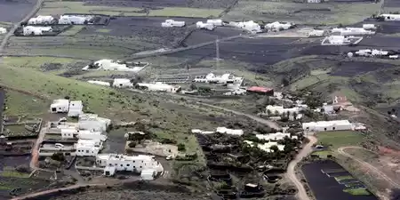
The Municipality of Tías is formed by the towns of Tías, Puerto del Carmen, La Asomada, Mácher, Conil, Masdache and Vega de Tegoyo.
The nucleus of this municipality was formed by initially around the houses of the landowners who, during the Old Regime, dominated the area. They were the ones who left their names in the toponymy.
The family that gives its name to the place is that of Fajardo; Specifically, two matrons of the old manor: Doña Francisca and Doña Hernán, single, related to the Governor of Gran Canaria Alonso Fajardo. The surname Molina was the basis of another nearby nucleus, as well like that of Robayna; today these three groups form a single place, that of Tías de Fajardo, having now forgotten the surname.
According to Millares Torres, the parish, under the patronage of Nuestra Señora de Candelaria, was erected as such in 1796, when it was segregated. of that of San Bartolomé. The temple had been attempted to be built in 1618, although it was in 1796 when it was erected. elsewhere, being restored by Bishop Urquinaona in 1872.
La Tiñosa had a singular importance in municipal history, a natural port of special importance in the years of splendor of La Barilla, in the 18th century.
Tías obtained its administrative independence on July 5, 1799, creating its town hall separate from that of Teguise.
Located in the eastern part of the island, it limits to the northeast with San Bartolomé, following an almost straight line. that goes from the Juan Bello Mountain to the Guasimeta Beach and that divides the airport facilities. Towards the northwest in the central zone of the island, it adjoins Tinajo, through another straight line, which cuts through the Black Mountain. Finally, to the west, this line bends, taking the summit of the Guardilama mountain as a reference and descends through the Pila ravine to the sea.
The coastal strip, which covers the entire southern part of the municipality, has a more cliffed western section, while from Punta Tiñosa to Guasimeta, it is a succession of sandy beaches, which precisely lead, in as a whole, this name: Las Playas.
A good part of the term is occupied by recent volcanic materials, belonging to the Second Volcanic Cycle, and even historical. There are also some residual reliefs, in the form of hills, which correspond to ancient basalts, emitted in the First Volcanic Cycle of the island's formation.
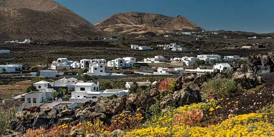
Inland, in contact with Tinajo, is La Geria, which is an intercolinar valley, covered with recent volcanic materials from the eruptions of the 18th century. It is one of the most representative and unique agricultural landscapes on the island, where the peasant has had to dig in the sand (picon or lapilli), or even the lava, until he finds fertile soil where he can plant his crops.
Continuing towards the coast, numerous aligned volcanic cones appear; among which are a series of fertile plains, which represent the most fertile spaces, and where a good number of crops are developed and, on its edges, population centers, including the municipal capital.
A gentle slope continues down to the coast. where it would run, until it reached the sea, near La Tiñosa, one of the two lava flows from the 1730-36 eruptions, which reached this part of the island.
The development of tourist activity has transformed the coastline, which has been subjected to a progressive urbanization process. It has not been without controversy, in the case of the constructions of Los Pocillos or those that ended with Las Salinas de Matagorda. Aridity is the dominant note of the climate, where the low altitude of the entire term does not allow greater contrasts to exist. Only the highest spaces in the interior experience greater amounts of humidity.
The original plant cover has been completely transformed by the introduction of crops and urbanization; without ruling out occupation due to historical eruptions.
Although until a few decades ago the base of the municipal economy was agriculture, today tourism occupies the first place.
This has given rise to different social phenomena, such as the decrease in the working population of the primary sector with an increase in the tertiary sector.
In the agrarian space there are well differentiated zones. Thus, La Geria, with its peculiar cultivation system, is dedicated to the vine, while Las Vegas is devoted to subsistence products. The middle zone, until recently devoted to tomatoes, now grows onions for export. The land that was previously occupied by grazing now contemplates buildings dedicated to tourism.
This tourism is located in the areas of Las Playas, with fine sand and ideal weather.
Finally, fishing is located in Puerto del Carmen, current name of La Tiñosa.
An original custom has been rescued, known as La Santa, in relation to Santa Lucía, and which traditionally took place throughout the south of the island, towards the end of November, and until December 24 . This festival dates back some 250 years, its origin being in the particular promises made to the aforementioned Saint. While St. Lucia was being veiled, young people of Mosiar age took advantage of these occasions to perform a series of relationship games, even ending with the celebration of a dance.
El Rancho de Pascuas picks up the tradition of this type of musical groups, with a series of unique songs, of very ancient origin: lamentations or rejections, contradanza,...
The different musical groups of the municipality also maintain a folklore of peculiar nuances.
Within the artisanal production we can find lacework and basketry. Excellent are the wines of La Geria.
The most outstanding points to be visited in the municipality of Tías are its temples.
The northern sector of the municipality is included in the La Geria Natural Park. Area affected by the eruptions of 1730-36, where a clear sign of integration of man in the environment is offered. Hundreds of small cones, excavated by the peasants, give shelter to the vines, which are protected from the prevailing wind by a small stone wall. In other cases, the same lava flows have been excavated, until fertile soil has been found, where almost miraculously, the crops prosper.
The wide coastal cord, with a succession of beaches, has, as well itself, natural interest and, fundamentally, recreational.
The municipality of Tías is made up of six population centers, each offering a different perspective of life on Lanzarote. These include the bustling tourist hub of Puerto del Carmen, the historic town of Tías, as well as Mácher, La Asomada, Conil, and Masdache.
From the vibrant beaches and nightlife of Puerto del Carmen to the peaceful vineyards and rural landscapes of the inland villages, the towns of Tías combine tradition and tourism in a unique way. It's a place where visitors can enjoy both the energy of the coast and the calm charm of Lanzarote's countryside.
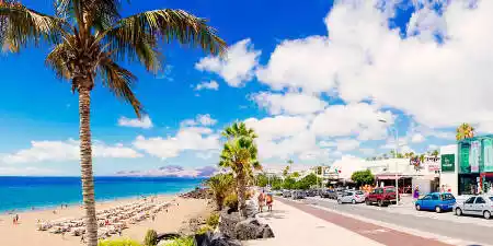
Puerto del Carmen It was a fishing village around which the most important tourist center of Lanzarote arose.

The town of La Asomada is located on the slopes of the volcano known as Montaña de Gaida.


Promoción y turismo en internet