The Riscos de Famara, with its impressive walls vertical, they are the main mountainous massif of Lanzarote, in the north of the island, between the municipalities of Teguise and Would. Here is the Peñas del Chache mountain, which is the highest point on the island, with 670 meters of altitude.
It has a cliff with views of the Famara beach, the largest in Lanzarote, with white sand and a very rough sea, making it dangerous bathe in it. You can practice surf and kitesurf if you are an expert .
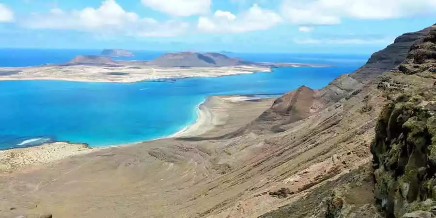
Further north is the Mirador del Río, the work of the artist César Manrique, where you can get a wide view of the islets that make up the Chinijo Archipelago.
Also here, under the Risco, there are some salt flats, now abandoned, and a virgin white sand beach, the Playa del Risco. Nearby is the road that for many years served as the main link, once El Río was crossed, with the island of La Graciosa, known as like the camino de los gracioceros.
The Riscos de Famara are one of the best areas on the island to practice paragliding and hang gliding, lovers of this sport launch themselves into free flight from the heights to gently descend over the cliffs until landing on the beach.The cliffs of Famara have been defined as a true ecological island, home to most of the ecosystems present in Lanzarote.
On the other hand, this is the area with the richest waters in Lanzarote, with the presence of springs and where some galleries were drilled.
The sum of the natural and landscape values of the cliffs and islets determined its classification as a Natural Park. Delimitation that extends beyond Famara Beach, in a sector largely occupied by jable (sand) of marine origin.
Promoción y turismo en internet